


| The World Factbook | ||
|
|
Peru |
|
|
| Introduction | Peru |
|
Background:
|
Ancient Peru was the seat of several prominent Andean civilizations, most notably that of the Incas whose empire was captured by the Spanish conquistadors in 1533. Peruvian independence was declared in 1821, and remaining Spanish forces defeated in 1824. After a dozen years of military rule, Peru returned to democratic leadership in 1980, but experienced economic problems and the growth of a violent insurgency. President Alberto FUJIMORI's election in 1990 ushered in a decade that saw a dramatic turnaround in the economy and significant progress in curtailing guerrilla activity. Nevertheless, the president's increasing reliance on authoritarian measures and an economic slump in the late 1990s generated mounting dissatisfaction with his regime, which led to his ouster in 2000. A caretaker government oversaw new elections in the spring of 2001, which ushered in Alejandro TOLEDO Manrique as the new head of government - Peru's first democratically elected president of Native American ethnicity. The presidential election of 2006 saw the return of Alan GARCIA Perez who, after a disappointing presidential term from 1985 to 1990, has overseen a robust macroeconomic performance. |
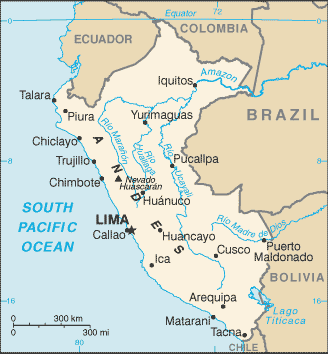
| Geography | Peru |
|
Location:
|
Western South America, bordering the South Pacific Ocean, between Chile and Ecuador |
|
Geographic coordinates:
|
10 00 S, 76 00 W |
|
Map references:
|
South America |
|
Area:
|
total: 1,285,220 sq km
land: 1.28 million sq km water: 5,220 sq km |
|
Area - comparative:
|
slightly smaller than Alaska |
|
Land boundaries:
|
total: 7,461 km
border countries: Bolivia 1,075 km, Brazil 2,995 km, Chile 171 km, Colombia 1,800 km, Ecuador 1,420 km |
|
Coastline:
|
2,414 km |
|
Maritime claims:
|
territorial sea: 200 nm
continental shelf: 200 nm |
|
Climate:
|
varies from tropical in east to dry desert in west; temperate to frigid in Andes |
|
Terrain:
|
western coastal plain (costa), high and rugged Andes in center (sierra), eastern lowland jungle of Amazon Basin (selva) |
|
Elevation extremes:
|
lowest point: Pacific Ocean 0 m
highest point: Nevado Huascaran 6,768 m |
|
Natural resources:
|
copper, silver, gold, petroleum, timber, fish, iron ore, coal, phosphate, potash, hydropower, natural gas |
|
Land use:
|
arable land: 2.88%
permanent crops: 0.47% other: 96.65% (2005) |
|
Irrigated land:
|
12,000 sq km (2003) |
|
Total renewable water resources:
|
1,913 cu km (2000) |
|
Freshwater withdrawal (domestic/industrial/agricultural):
|
total: 20.13 cu km/yr (8%/10%/82%)
per capita: 720 cu m/yr (2000) |
|
Natural hazards:
|
earthquakes, tsunamis, flooding, landslides, mild volcanic activity |
|
Environment - current issues:
|
deforestation (some the result of illegal logging); overgrazing of the slopes of the costa and sierra leading to soil erosion; desertification; air pollution in Lima; pollution of rivers and coastal waters from municipal and mining wastes |
|
Environment - international agreements:
|
party to: Antarctic-Environmental Protocol, Antarctic-Marine Living Resources, Antarctic Treaty, Biodiversity, Climate Change, Climate Change-Kyoto Protocol, Desertification, Endangered Species, Hazardous Wastes, Marine Dumping, Ozone Layer Protection, Ship Pollution, Tropical Timber 83, Tropical Timber 94, Wetlands, Whaling
signed, but not ratified: none of the selected agreements |
|
Geography - note:
|
shares control of Lago Titicaca, world's highest navigable lake, with Bolivia; a remote slope of Nevado Mismi, a 5,316 m peak, is the ultimate source of the Amazon River |
| People | Peru |
|
Population:
|
29,546,963 (July 2009 est.) |
|
Age structure:
|
0-14 years: 29.1% (male 4,370,923/female 4,216,364)
15-64 years: 65.2% (male 9,695,270/female 9,574,018) 65 years and over: 5.7% (male 796,631/female 893,757) (2009 est.) |
|
Median age:
|
total: 26.1 years
male: 25.8 years female: 26.4 years (2009 est.) |
|
Population growth rate:
|
1.229% (2009 est.) |
|
Birth rate:
|
19.38 births/1,000 population (2009 est.) |
|
Death rate:
|
6.16 deaths/1,000 population (2008 est.) |
|
Net migration rate:
|
-0.95 migrant(s)/1,000 population (2009 est.) |
|
Urbanization:
|
urban population: 71% of total population (2008)
rate of urbanization: 1.3% annual rate of change (2005-10 est.) |
|
Sex ratio:
|
at birth: 1.05 male(s)/female
under 15 years: 1.04 male(s)/female 15-64 years: 1.01 male(s)/female 65 years and over: 0.89 male(s)/female total population: 1.01 male(s)/female (2009 est.) |
|
Infant mortality rate:
|
total: 28.62 deaths/1,000 live births
male: 31.07 deaths/1,000 live births female: 26.06 deaths/1,000 live births (2009 est.) |
|
Life expectancy at birth:
|
total population: 70.74 years
male: 68.88 years female: 72.69 years (2009 est.) |
|
Total fertility rate:
|
2.37 children born/woman (2009 est.) |
|
HIV/AIDS - adult prevalence rate:
|
0.5% (2007 est.) |
|
HIV/AIDS - people living with HIV/AIDS:
|
76,000 (2007 est.) |
|
HIV/AIDS - deaths:
|
3,300 (2007 est.) |
|
Major infectious diseases:
|
degree of risk: very high
food or waterborne diseases: bacterial, hepatitis A, and typhoid fever vectorborne disease: dengue fever, malaria, and yellow fever water contact disease: leptospirosis (2009) |
|
Nationality:
|
noun: Peruvian(s)
adjective: Peruvian |
|
Ethnic groups:
|
Amerindian 45%, mestizo (mixed Amerindian and white) 37%, white 15%, black, Japanese, Chinese, and other 3% |
|
Religions:
|
Roman Catholic 81.3%, Evangelical 12.5%, other 3.3%, unspecified or none 2.9% (2007 Census) |
|
Languages:
|
Spanish (official), Quechua (official), Aymara, and a large number of minor Amazonian languages |
|
Literacy:
|
definition: age 15 and over can read and write
total population: 92.9% male: 96.4% female: 89.4% (2007 Census) |
|
School life expectancy (primary to tertiary education):
|
total: 14 years
male: 14 years female: 14 years (2006) |
|
Education expenditures:
|
2.5% of GDP (2006) |
| Government | Peru |
|
Country name:
|
conventional long form: Republic of Peru
conventional short form: Peru local long form: Republica del Peru local short form: Peru |
|
Government type:
|
constitutional republic |
|
Capital:
|
name: Lima
geographic coordinates: 12 03 S, 77 03 W time difference: UTC-5 (same time as Washington, DC during Standard Time) |
|
Administrative divisions:
|
25 regions (regiones, singular - region) and 1 province* (provincia); Amazonas, Ancash, Apurimac, Arequipa, Ayacucho, Cajamarca, Callao, Cusco, Huancavelica, Huanuco, Ica, Junin, La Libertad, Lambayeque, Lima, Lima*, Loreto, Madre de Dios, Moquegua, Pasco, Piura, Puno, San Martin, Tacna, Tumbes, Ucayali |
|
Independence:
|
28 July 1821 (from Spain) |
|
National holiday:
|
Independence Day, 28 July (1821) |
|
Constitution:
|
29 December 1993 |
|
Legal system:
|
based on civil law system; accepts compulsory ICJ jurisdiction with reservations |
|
Suffrage:
|
18 years of age; universal and compulsory until the age of 70; note - for the first time in recent elections, members of the military and national police were eligible to vote in the 2006 elections |
|
Executive branch:
|
chief of state: President Alan GARCIA Perez (since 28 July 2006); First Vice President Luis GIAMPIETRI Rojas (since 28 July 2006); Second Vice President Lourdes MENDOZA del Solar (since 28 July 2006); note - the president is both the chief of state and head of government
head of government: President Alan GARCIA Perez (since 28 July 2006); First Vice President Luis GIAMPIETRI Rojas (since 28 July 2006); Second Vice President Lourdes MENDOZA del Solar (since 28 July 2006) note: Prime Minister Yehude SIMON Munaro (since 14 October 2008) does not exercise executive power; this power is in the hands of the president cabinet: Council of Ministers appointed by the president elections: president elected by popular vote for a five-year term (eligible for a nonconsecutive reelection); presidential and congressional elections held 9 April 2006 with runoff election held 4 June 2006; next to be held in April 2011 election results: Alan GARCIA Perez elected president in runoff election; percent of vote - Alan GARCIA Perez 52.5%, Ollanta HUMALA Tasso 47.5% |
|
Legislative branch:
|
unicameral Congress of the Republic of Peru or Congreso de la Republica del Peru (120 seats; members are elected by popular vote to serve five-year terms)
elections: last held 9 April 2006 (next to be held in April 2011) election results: percent of vote by party - UPP 21.2%, PAP 20.6%, UN 15.3%, AF 13.1%, FC 7.1%, PP 4.1%, RN 4.0%, other 14.6%; seats by party - UPP 45, PAP 36, UN 17, AF 13, FC 5, PP 2, RN 2 |
|
Judicial branch:
|
Supreme Court of Justice or Corte Suprema de Justicia (judges are appointed by the National Council of the Judiciary) |
|
Political parties and leaders:
|
Alliance For Progress (Alianza Para El Progreso) [Cesar ACUNA Peralta]; Alliance For The Future (Alianza Por El Futuro) or AF (a coalition of pro-FUJIMORI parties including Cambio 90, Nueva Mayoria, and Si Cumple); Central Front (Frente Del Centro) or FC (a coalition of Accion Popular, Somos Peru, and Coordinadora Nacional de Independientes) [Victor Andres GARCIA Belaunde]; National Renovation Party (Partido Renovacion Nacional) [Rafael REY]; National Restoration Party (Restauracion Nacional) or RN [Humberto LAY Sun]; National Solidarity Party (Partido Solidaridad Nacional) or SN [Luis CASTANEDA Lossio]; Peru Possible (Peru Posible) or PP [Alejandro TOLEDO Manrique]; Peruvian Aprista Party (Partido Aprista Peruano) or PAP [Alan GARCIA Perez] (also referred to by its original name Alianza Popular Revolucionaria Americana or APRA); Peruvian Nationalist Party (Partido Nacionalista Peruano) or PNP [Ollanta HUMALA Tasso]; Popular Christian Party (Partido Popular Cristiano) or PPC [Lourdes FLORES Nano]; Union for Peru (Union por el Peru) or UPP [Aldo ESTRADA Choque] |
|
Political pressure groups and leaders:
|
General Workers Confederation of Peru (Confederacion General de Trabajadores del Peru) or CGTP [Mario HUAMAN]; Shining Path (Sendero Luminoso) or SL [Abimael GUZMAN Reynoso (imprisoned), Victor QUISPE Palomino (top leader at-large)] (leftist guerrilla group) |
|
International organization participation:
|
APEC, CAN, FAO, G-15, G-24, G-77, IADB, IAEA, IBRD, ICAO, ICCt, ICRM, IDA, IFAD, IFC, IFRCS, IHO, ILO, IMF, IMO, IMSO, Interpol, IOC, IOM, IPU, ISO, ITSO, ITU, ITUC, LAES, LAIA, Mercosur (associate), MIGA, MINUSTAH, MONUC, NAM, OAS, OPANAL, OPCW, PCA, RG, UN, UNASUR, UNCTAD, UNESCO, UNIDO, Union Latina, UNMIL, UNMIS, UNOCI, UNWTO, UPU, WCL, WCO, WFTU, WHO, WIPO, WMO, WTO |
|
Diplomatic representation in the US:
|
chief of mission: Ambassador Luis VALDIVIESO Montano
chancery: 1700 Massachusetts Avenue NW, Washington, DC 20036 telephone: [1] (202) 833-9860 through 9869 FAX: [1] (202) 659-8124 consulate(s) general: Atlanta, Boston, Chicago, Denver, Hartford, Houston, Los Angeles, Miami, New York, Paterson (New Jersey), San Francisco, Washington, DC |
|
Diplomatic representation from the US:
|
chief of mission: Ambassador P. Michael MCKINLEY
embassy: Avenida La Encalada, Cuadra 17s/n, Surco, Lima 33 mailing address: P. O. Box 1995, Lima 1; American Embassy (Lima), APO AA 34031-5000 telephone: [51] (1) 434-3000 FAX: [51] (1) 618-2397 |
|
Flag description:
|
three equal, vertical bands of red (hoist side), white, and red with the coat of arms centered in the white band; the coat of arms features a shield bearing a vicuna, cinchona tree (the source of quinine), and a yellow cornucopia spilling out gold coins, all framed by a green wreath |
| Economy | Peru |
|
Economy - overview:
|
Peru's economy reflects its varied geography - an arid coastal region, the Andes further inland, and tropical lands bordering Colombia and Brazil. Abundant mineral resources are found in the mountainous areas, and Peru's coastal waters provide excellent fishing grounds. The Peruvian economy grew by more than 4% per year during the period 2002-06, with a stable exchange rate and low inflation. Growth jumped to 9% per year in 2007 and 2008, driven by higher world prices for minerals and metals and the government's aggressive trade liberalization strategies. Peru's rapid expansion has helped to reduce the national poverty rate by about 15% since 2002, though underemployment and inflation remain high. Despite Peru's strong macroeconomic performance, overdependence on minerals and metals subjects the economy to fluctuations in world prices, and poor infrastructure precludes the spread of growth to Peru's non-coastal areas. Not all Peruvians therefore have shared in the benefits of growth. President GARCIA's pursuit of sound trade and macroeconomic policies has cost him political support since his election. Nevertheless, he remains committed to Peru's free-trade path. The United States and Peru completed negotiations on the implementation of the U.S.-Peru Trade Promotion Agreement (PTPA), and the agreement entered into force February 1, 2009, opening the way to greater trade and investment between the two economies. |
|
GDP (purchasing power parity):
|
$238.9 billion (2008 est.)
$218.8 billion (2007) $206.6 billion (2006) note: data are in 2008 US dollars |
|
GDP (official exchange rate):
|
$131.4 billion (2008 est.) |
|
GDP - real growth rate:
|
9.2% (2008 est.)
9% (2007 est.) 7.6% (2006 est.) |
|
GDP - per capita (PPP):
|
$8,400 (2008 est.)
$7,800 (2007 est.) $7,300 (2006 est.) note: data are in 2008 US dollars |
|
GDP - composition by sector:
|
agriculture: 8.5%
industry: 21.2% services: 70.3% (2008 est.) |
|
Labor force:
|
10.2 million (2008 est.) |
|
Labor force - by occupation:
|
agriculture: 0.7%
industry: 23.8% services: 75.5% (2005) |
|
Unemployment rate:
|
8.4% in metropolitan Lima; widespread underemployment (2008 est.) |
|
Population below poverty line:
|
44.5% (2006) |
|
Household income or consumption by percentage share:
|
lowest 10%: 1.3%
highest 10%: 40.9% (2003) |
|
Distribution of family income - Gini index:
|
49.8 (2005) |
|
Investment (gross fixed):
|
24.4% of GDP (2008 est.) |
|
Budget:
|
revenues: $38.83 billion
expenditures: $35.5 billion (2008 est.) |
|
Fiscal year:
|
calendar year |
|
Public debt:
|
24.1% of GDP (2008 est.) |
|
Inflation rate (consumer prices):
|
6.7% (2008 est.) |
|
Central bank discount rate:
|
6.5% (December 2008) |
|
Commercial bank prime lending rate:
|
24.1% (December 2008) |
|
Stock of money:
|
$14.66 billion (31 December 2007) |
|
Stock of quasi money:
|
$19.95 billion (31 December 2007) |
|
Stock of domestic credit:
|
$17.88 billion (31 December 2007) |
|
Market value of publicly traded shares:
|
$57.23 billion (31 July 2008) |
|
Agriculture - products:
|
asparagus, coffee, cocoa, cotton, sugarcane, rice, potatoes, corn, plantains, grapes, oranges, pineapples, guavas, bananas, apples, lemons, pears, coca, tomatoes, mango, barley, medicinal plants, palm oil, marigold, onion, wheat, dry beans; poultry, beef, dairy products; fish, guinea pigs |
|
Industries:
|
mining and refining of minerals; steel, metal fabrication; petroleum extraction and refining, natural gas; fishing and fish processing, textiles, clothing, food processing |
|
Industrial production growth rate:
|
4.5% (2008 est.) |
|
Electricity - production:
|
30.57 billion kWh (2008 est.) |
|
Electricity - consumption:
|
28.97 billion kWh (2008 est.) |
|
Electricity - exports:
|
0 kWh (2008 est.) |
|
Electricity - imports:
|
0 kWh (2008 est.) |
|
Electricity - production by source:
|
fossil fuel: 14.5%
hydro: 84.7% nuclear: 0% other: 0.8% (2001) |
|
Oil - production:
|
110,800 bbl/day (2008 est.) |
|
Oil - consumption:
|
170,000 bbl/day (2007 est.) |
|
Oil - exports:
|
27,390 bbl/day (2007 est.) |
|
Oil - imports:
|
109,000 bbl/day (2007 est.) |
|
Oil - proved reserves:
|
930 million bbl (1 January 2008 est.) |
|
Natural gas - production:
|
3.4 billion cu m (2008 est.) |
|
Natural gas - consumption:
|
3.4 billion cu m (2008 est.) |
|
Natural gas - exports:
|
0 cu m (2008 est.) |
|
Natural gas - imports:
|
0 cu m (2008 est.) |
|
Natural gas - proved reserves:
|
334.7 billion cu m (1 January 2008 est.) |
|
Current account balance:
|
-$3.631 billion (2008 est.) |
|
Exports:
|
$33.27 billion f.o.b. (2008 est.) |
|
Exports - commodities:
|
copper, gold, zinc, crude petroleum and petroleum products, coffee, potatoes, asparagus, textiles, fishmeal |
|
Exports - partners:
|
US 19.5%, China 12.7%, Canada 7.6%, Japan 7.5%, Chile 5.9%, Switzerland 4.2%, Spain 4.1% (2007) |
|
Imports:
|
$29.08 billion f.o.b. (2008 est.) |
|
Imports - commodities:
|
petroleum and petroleum products, plastics, machinery, vehicles, iron and steel, wheat, paper |
|
Imports - partners:
|
US 20.5%, China 10.8%, Brazil 9%, Ecuador 6.1%, Argentina 5.6%, Chile 5%, Colombia 4.8% (2007) |
|
Reserves of foreign exchange and gold:
|
$31.79 billion (31 December 2008 est.) |
|
Debt - external:
|
$35.46 billion (31 December 2008 est.) |
|
Stock of direct foreign investment - at home:
|
$32.14 billion (2008 est.) |
|
Stock of direct foreign investment - abroad:
|
$1.476 billion (2008 est.) |
|
Currency (code):
|
nuevo sol (PEN) |
|
Currency code:
|
PEN |
|
Exchange rates:
|
nuevo sol (PEN) per US dollar - 2.91 (2008 est.), 3.1731 (2007), 3.2742 (2006), 3.2958 (2005), 3.4132 (2004) |
| Communications | Peru |
|
Telephones - main lines in use:
|
2.673 million (2007) |
|
Telephones - mobile cellular:
|
15.417 million (2007) |
|
Telephone system:
|
general assessment: adequate for most requirements
domestic: fixed-line teledensity is only about 9 per 100 persons; mobile-cellular teledensity, spurred by competition among multiple providers, has increased to roughly 55 telephones per 100 persons; nationwide microwave radio relay system and a domestic satellite system with 12 earth stations international: country code - 51; the South America-1 (SAM-1) and Pan American (PAN-AM) submarine cable systems provide links to parts of Central and South America, the Caribbean, and US; satellite earth stations - 2 Intelsat (Atlantic Ocean) |
|
Radio broadcast stations:
|
AM 472, FM 198, shortwave 189 (1999) |
|
Radios:
|
6.65 million (1997) |
|
Television broadcast stations:
|
13 (plus 112 repeaters) (1997) |
|
Televisions:
|
3.06 million (1997) |
|
Internet country code:
|
.pe |
|
Internet hosts:
|
271,745 (2008) |
|
Internet Service Providers (ISPs):
|
10 (2000) |
|
Internet users:
|
7.636 million (2007) |
| Transportation | Peru |
|
Airports:
|
202 (2008) |
|
Airports - with paved runways:
|
total: 56
over 3,047 m: 6 2,438 to 3,047 m: 20 1,524 to 2,437 m: 15 914 to 1,523 m: 11 under 914 m: 4 (2008) |
|
Airports - with unpaved runways:
|
total: 146
2,438 to 3,047 m: 2 1,524 to 2,437 m: 24 914 to 1,523 m: 39 under 914 m: 81 (2008) |
|
Heliports:
|
1 (2007) |
|
Pipelines:
|
extra heavy crude 533 km; gas 1,078 km; liquid petroleum gas 654 km; oil 1,018 km; refined products 15 km (2008) |
|
Railways:
|
total: 1,989 km
standard gauge: 1,726 km 1.435-m gauge narrow gauge: 263 km 0.914-m gauge (2006) |
|
Roadways:
|
total: 78,829 km
paved: 11,351 km (includes 276 km of expressways) unpaved: 67,478 km (2004) |
|
Waterways:
|
8,808 km
note: 8,600 km of navigable tributaries of Amazon system and 208 km of Lago Titicaca (2008) |
|
Merchant marine:
|
total: 8
by type: cargo 3, chemical tanker 1, petroleum tanker 4 foreign-owned: 1 (Bahamas 1) registered in other countries: 17 (Belize 1, Panama 16) (2008) |
|
Ports and terminals:
|
Callao, Iquitos, Matarani, Paita, Pucallpa, Yurimaguas; note - Iquitos, Pucallpa, and Yurimaguas are on the upper reaches of the Amazon and its tributaries |
| Military | Peru |
|
Military branches:
|
Army of Peru (Ejercito Peruano), Navy of Peru (Marina de Guerra del Peru, MGP (includes naval air, naval infantry, and Coast Guard)), Air Force of Peru (Fuerza Aerea del Peru, FAP) (2008) |
|
Military service age and obligation:
|
18-30 years of age for voluntary male and female military service; no conscription (2008) |
|
Manpower available for military service:
|
males age 16-49: 7,653,898
females age 16-49: 7,531,329 (2008 est.) |
|
Manpower fit for military service:
|
males age 16-49: 5,920,716
females age 16-49: 6,359,803 (2009 est.) |
|
Manpower reaching militarily significant age annually:
|
male: 310,575
female: 300,838 (2009 est.) |
|
Military expenditures:
|
1.5% of GDP (2006) |
| Transnational Issues | Peru |
|
Disputes - international:
|
Chile and Ecuador rejected Peru's November 2005 unilateral legislation to shift the axis of their joint treaty-defined maritime boundaries along the parallels of latitude to equidistance lines which favor Peru; organized illegal narcotics operations in Colombia have penetrated Peru's shared border; Peru rejects Bolivia's claim to restore maritime access through a sovereign corridor through Chile along the Peruvian border |
|
Refugees and internally displaced persons:
|
IDPs: 60,000-150,000 (civil war from 1980-2000; most IDPs are indigenous peasants in Andean and Amazonian regions) (2007) |
|
Illicit drugs:
|
until 1996 the world's largest coca leaf producer, Peru is now the world's second largest producer of coca leaf, though it lags far behind Colombia; cultivation of coca in Peru declined to 36,000 hectares in 2007; second largest producer of cocaine, estimated at 210 metric tons of potential pure cocaine in 2007; finished cocaine is shipped out from Pacific ports to the international drug market; increasing amounts of base and finished cocaine, however, are being moved to Brazil, Chile, Argentina, and Bolivia for use in the Southern Cone or transshipment to Europe and Africa; increasing domestic drug consumption |
|
This page was last updated on 14 May, 2009 |